Antiquity | The Ypres Salient 1914–1918

Map of the Ypres Salient with selected features such as mine craters, shelters (light shelters and open-air shelters), gun emplacements and concrete bunkers. Trenches are shown as a kernel density map

(Antiquity, 2017)

The Ypres Salient 1914–1918: historical aerial photography and the landscape of war

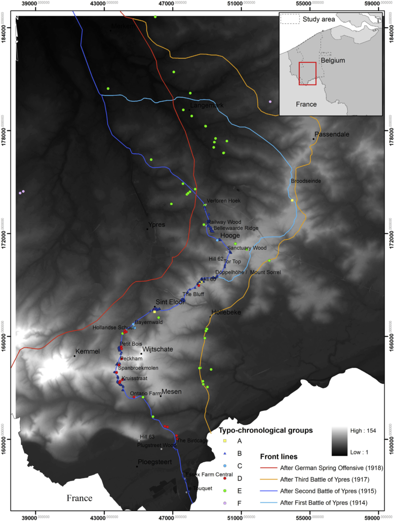
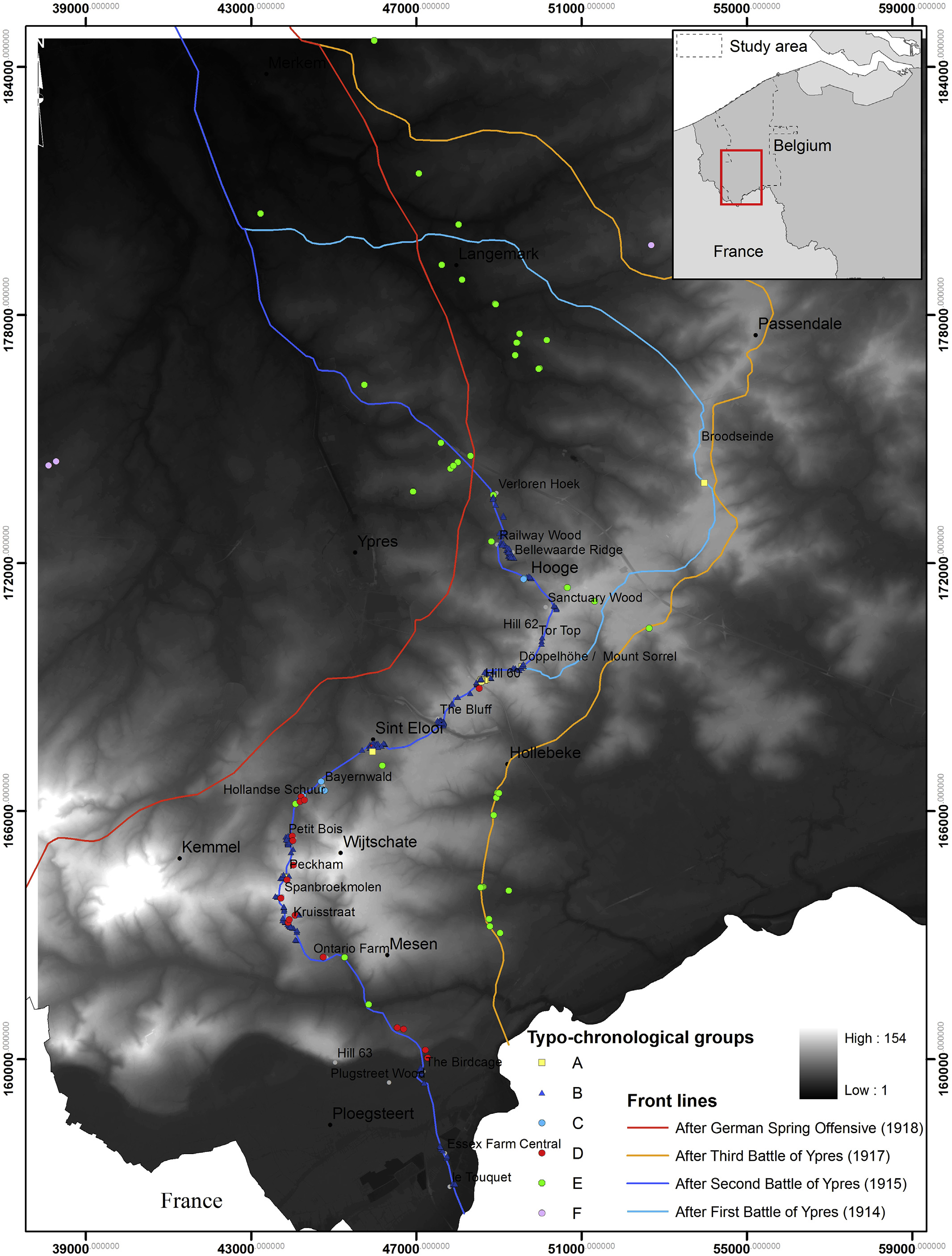
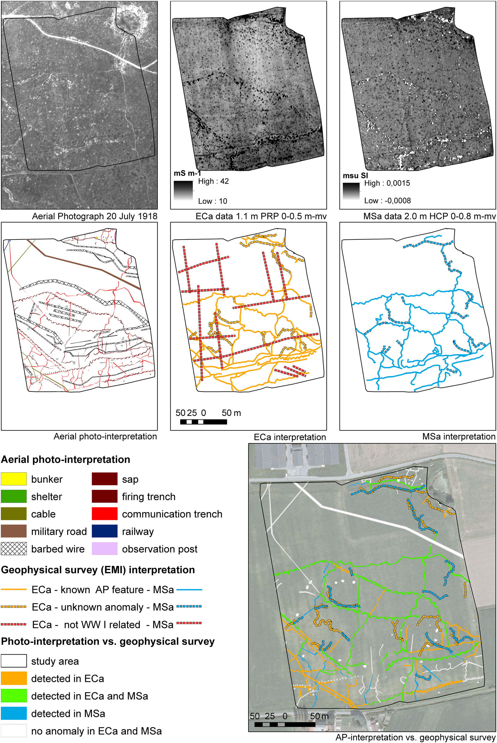
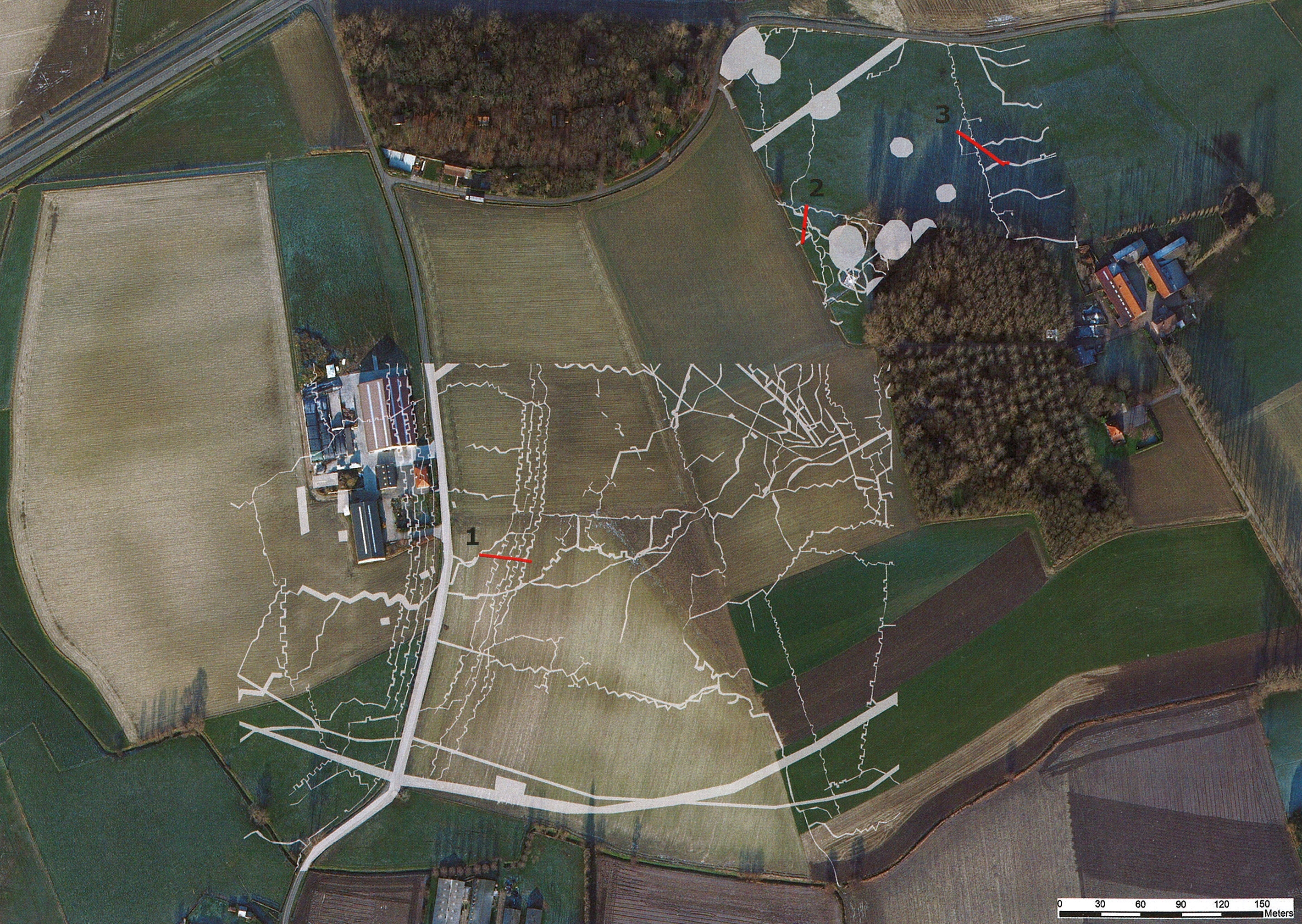
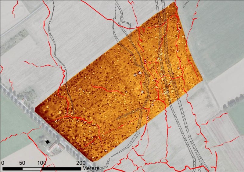
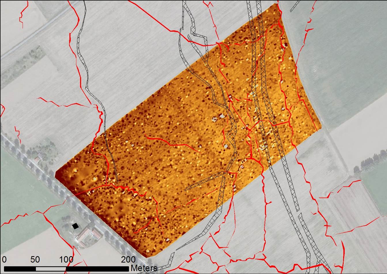
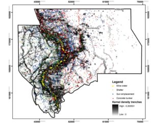
As the centenary commemorations of the Battle of Passchendaele approach, this article is a timely demonstration of how archaeology can provide new insights into the landscape of the Western Front. Assessment of over 9000 aerial photographs taken during the First World War, integrated with other approaches to landscape archaeology, offers a new perspective on the shifting nature of the historic struggle around the town of Ypres in Belgium. The results not only illustrate the changing face of the landscape over that four-year period, but also highlight the potential of aerial photographic records to illuminate hitherto overlooked aspects of landscape heritage.

Reference:

Stichelbaut, B., Gheyle, W., Van Eetvelde, V., Van Meirvenne, Saey, T., M., Note, N., Van den Berghe, H. & Bourgeois, J. (2016). The Ypres Salient 1914–1918: historical aerial photography and the landscape of war. Antiquity, 91 (355), 235-249. doi: 10.15184/aqy.2016.260

Geoarchaeology | Multireceiver EMI on a WWI battlefield

Modeled electrical conductivity (σ) of the layer in-between 0.4 and 0.8 m depth (a) and below 0.8 m depth (b)

(Geoarchaeology, 2016)

The Characterization of a Former World War I Battlefield by Integrating Multiple Signals from a Multireceiver EMI Soil Sensor

World War I (WWI) battlefields contain a large diversity of buried features that are situated just below the plough layer. A noninvasive interdisciplinary approach is preferred to characterize the buried heritage embedded within its soil landscape. In this study, the potential of integrating both electrical conductivity and magnetic susceptibility measurements from a multireceiver electromagnetic induction (EMI) instrument at a heavily shelled WWI battlefield was evaluated. Primarily, both measurements allowed the attribution of approximate depth interval to the buried trench remains. These remains proved dominantly present within the 0.4–0.8 m depth interval. Subsequently, both apparent electrical conductivity and magnetic susceptibility measurements were separately integrated to improve the contrast between buried features and their surrounding background. Trenches that were ditches filled with topsoil material could be distinguished from trenches that were continuously or partially filled with metal reinforcements or debris. To conclude, integrating multiple signals from a multireceiver EMI system allowed for a more straightforward
discrimination of the buried WWI relicts.

Reference:

Saey, T., Gheyle, W., Stichelbaut, B., Bourgeois, J., Verplaetse, S., Van Eetvelde, V., Note, N. & Van Meirvenne, M. (2016). The Characterization of a Former World War I Battlefield by Integrating Multiple Signals from a Multireceiver EMI Soil Sensor. Geoarchaeology, 31 (4), 267-281. doi:

Applied Geography | Mine craters in the Ypres Salient

Distribution map of typo-chronological groups of mine craters related to the successive front lines in the Ypres Salient (source DTM: Open data Flemish Agency for Spatial Information)).

(Applied Geography, 2016)

The First World War from above and below. Historical aerial photographs and mine craters in the Ypres Salient

During the First World War, ancient siege techniques were used in an attempt to break through the stalemate in the trenches. This paper approaches the mine crater war from a completely new perspective and focuses on a landscape-scale approach rather than on fragmented individual sites. Thousands of contemporary aerial photographs have been used as a primary source of information to detect and understand the historical mine crater landscape along the former Western Front in Belgium. The paper presents a methodology for dating war features by means of a time series analysis of aerial photographs, confronting this historical landscape with a high-resolution Airborne Laser Scanning (ALS) dataset.

Reference:

Stichelbaut, B., Gheyle, W., Saey, T., Van Eetvelde, V., Van Meirvenne, M., Note, N., Van den Berghe, H. & Bourgeois, J. (2016). The First World War from above and below. Historical aerial photographs and mine craters in the Ypres Salient. Applied Geography, 66, 64-72. doi: http://dx.doi.org/10.1016/j.apgeog.2015.11.020

Geoderma | WW I relicts and the soil environment

Modelled susceptibility (κ) between 0.4 and 0.8m depth κ2⁎ with indication of anomalies by buriedmetal (0–1.0 m) and shell holes and trench systems.

(Geoderma, 2016)

EMI as a non-invasive survey technique to account for the interaction between WW I relicts and the soil environment at the Western front

After the war, the greater part of the disturbed areas within the Western front zone of World War I (WW I) was taken back into culture. Even 100 years after date, it can be assumed that the soil within these areas still contains the traces of the war. To account for a thorough inventory of both the soil variability, the WW I relicts and the anthropogenic disturbances and to identify their interactions, a large-scale, non-invasive approach employing a multi-receiver frequency-domain EMI instrument was proposed. With this instrument, both lateral variations of the soil apparent electrical conductivity (σa) and apparent magnetic susceptibility (κa) from multiple overlapping soil volumes were obtained at a battlefield site within the Western front zone. Inverting the multiple simultaneous σa measurements allowed for a detailed representation of the depth to the interface between both contrasting loess and clay layers at the study site. Additionally, anomalies caused by buried metal objects could be separated from more subtle anomalies caused by shell holes. Moreover, inverting the κa measurements improved the identification of different WW I trenches. Finally, the integration of all WW I and soil features allowed for an enhanced understanding about the impact of the war activities on the soil environment and vice-versa.

Reference:

Saey, T., Note, N., Gheyle, W., Stichelbaut, B., Bourgeois, J., Van Eetvelde, V., & Van Meirvenne, M. (2016). EMI as a non-invasive survey technique to account for the interaction between WW I relicts and the soil environment at the Western front. Geoderma, 265, 39-52. doi: http://dx.doi.org/10.1016/j.geoderma.2015.11.020

Book Chapter | World War I in Comines-Warneton

Location of Comines- Warneton along the Belgian front and indication of the fields surveyed with electromagnetic induction sensor (EMI). 1: Quatre-Rois, 2: La Plus Douve, 3: Chemin des Loups, 4: Chemin du Mont de la Hutte. © authors and AGIV: orthophoto mosaic 2009

(Book chapter, 2016)

The archaeology of World War I in Comines-Warneton (Belgium) through aerial photographs and proximal soil sensing

We have developed an integrated aerial archaeological and GIS-aided approach to assess the Great War heritage, combined with landscape research and geophysical prospection. Preliminary results suggest an excellent subsurface preservation of the conflict landscape, even after the devastating effect of the war itself and a century of reconstruction and land use. A case study at Comines-Warneton compares data derived from contemporary World War I aerial photographs with recent multi-receiver electromagnetic induction surveys. In addition, as most research traditionally has been devoted to the study of the trench systems, this chapter focusses on some of the less-studied, but equally important, aspects of the conflict landscape. These are sites such as war cemeteries, hospital sites and gun emplacements. This methodology will form the foundation for a wider study of the entire Belgian front zone – the interdisciplinary research project ‘Non- Invasive Landscape Archaeology of the Great War in Belgium’.

Reference:

Gheyle, W., T. Saey, Y. Van Hollebeeke, S. Verplaetse, N. Note, J. Bourgeois, M. Van Meirvenne, V. Van Eetvelde and B. Stichelbaut (2016). The archaeology of World War I in Comines-Warneton (Belgium) through aerial photographs and proximal soil sensing. In: D. Cowley and B. Stichelbaut (eds.) Conflict Landscapes and Archaeology from Above. Farnham, Ashgate Publishing: 11-28. http://www.tandf.net/books/details/9781472464385/

About the book:

The study of conflict archaeology has developed rapidly over the last decade, fuelled in equal measure by technological advances and creative analytical frameworks. Nowhere is this truer than in the inter-disciplinary fields of archaeological practice that combine traditional sources such as historical photographs and maps with 3D digital topographic data from Airborne Laser Scanning (ALS) and large scale geophysical prospection. For twentieth-century conflict landscapes and their surviving archaeological remains, these developments have encouraged a shift from a site oriented approach towards landscape-scaled research. This volume brings together an wide range of perspectives, setting traditional approaches that draw on historical and contemporary aerial photographs alongside cutting-edge prospection techniques, cross-disciplinary analyses and innovative methods of presenting this material to audiences. Essays from a range of disciplines (archaeology, history, geography, heritage and museum studies) studying conflict landscapes across the globe throughout the twentieth century, all draw on aerial and landscape perspectives to past conflicts and their legacy and the complex issues for heritage management. Organized in four parts, the first three sections take a broadly chronological approach, exploring the use of aerial evidence to expand our understanding of the two World Wars and the Cold War. The final section explores ways that the aerial perspective can be utilized to represent historical landscapes to a wide audience. With case studies ranging from the Western Front to the Cold War, Ireland to Russia, this volume demonstrates how an aerial perspective can both support and challenge traditional archaeological and historical analysis, providing an innovative new means of engaging with the material culture of conflict and commemoration.


Arch.Prosp. | Combining Aerial Photography and EMI

Mont de la Hutte with aerial photo-interpretation and geophysical survey: (top) British aerial photograph and EMI survey data (ECa and MSa measurements); (middle) interpretation of the aerial photographs and of the ECa and MSa measurements; (bottom) confrontation of photo-interpretation with geophysical data. © IWM Box Collection – Box 207 302 206 K 28U, © AGIV: orthophoto mosaic 2009 and authors
Mont de la Hutte with aerial photo-interpretation and EMI survey data (ECa and MSa measurements

(Archaeological Prospection, 2016)

Historical Aerial Photography and Multireceiver EMI Soil Sensing, Complementing Techniques for the Study of a Great War Conflict Landscape

This paper examines the combination of historical aerial photographic evidence and geophysical soil sensing. A case study in Comines-Warneton compares data derived from contemporary WWI aerial photographs with multi-receiver electromagnetic induction surveys. This comparison provides an understanding of the degree of preservation of trenches, dugouts and other military structures, and illustrates the added value of integrating both techniques in an in-depth, non-invasive study of conflict landscapes.

Reference:

Gheyle, W., Saey, T., Van Hollebeeke, Y., Verplaetse, S., Note, N., Bourgeois, J., Van Meirvenne, M., Van Eetvelde, V. & Stichelbaut, B. (2016). Historical Aerial Photography and Multi-receiver EMI Soil Sensing, Complementing Techniques for the Study of a Great War Conflict Landscape. Archaeological Prospection, doi:10.1002/arp.1534

M&L | Bellewaarde in the Great War

(Monumenten, Landschappen & Archeologie, 2014)

Bellewaarde en zijn turbulente oorlogsverleden

‘M&L – Monumenten, Landschappen & Archeologie’ (year 33, nr. 3) features an interesting study on the war history of Bellewaarde (Ypres). Especially Bellewaarde Wood, mostly untouched since 1918, hides many traces of the Great War. A combination of historical, archaeological and geophysical methods enabled the researchers to map many war traces, which make the war and the soldiers’ miserable conditions suddenly very tangible.

Marc Dewilde, Birger Stichelbaut, Yannick Van Hollebeeke, Hilde Verboven and Franky Wyffels, Bellewaarde en zijn turbulente oorlogsverleden

Arch.Prosp. | Non-invasive Landscape Archaeology

(Archaeological Prospection, 2013)

An Interdisciplinary Non-invasive Approach to Landscape Archaeology of the Great War

The prospection and evaluation of former battlefields of the Great War or the First World War (WW I) poses specific challenges. For several reasons, large-scale excavation campaigns of this conflict landscape are problematic. The vastness of the former Western Front (one of the largest archaeological sites in the world), the large amounts of buried unexploded ordnance and the possible presence of human remains hinder invasive practices. As an alternative, an integrated approach combining a geophysical survey, contemporary aerial photographs and a topographic model is proposed. This approach was evaluated for a 3.2 ha WW I battle field using a multireceiver electromagnetic induction (EMI) sensor. Integrating multiple apparent electrical conductivity (ECa) and apparent magnetic susceptibility (MSa) EMI measurements allowed evaluation of the present WW I remains in the subsoil, while comparison with WW I aerial photographs and a digital terrain model led to a comprehensive understanding of the WW I landscape. It is suggested that this approach may be of value for the investigation of battlefields in other locations and periods.

Reference:

Saey, T., Stichelbaut, B., Bourgeois, J., Van Eetvelde, V., & Van Meirvenne, M. (2013). An interdisciplinary non-invasive approach to landscape archaeology of the Great War. Archaeological Prospection 20 (1), 39–44. Published online 13 February 2013 in Wiley Online Library (wileyonlinelibrary.com) DOI: 10.1002/arp.1437

Book | The Great War Seen from the Air

The Great War Seen from the Air. In Flanders Fields, 1914–1918. By Birger Stichelbaut and Piet Chielens

(2014)

The Great War Seen from the Air – Stichelbaut, Birger; Chielens, Piet – Yale University Press.

This illuminating volume, the results of a collaboration between the In Flanders Fields Museum, Ypres, the Imperial War Museum, London, and the Royal Army Museum, Brussels, features hundreds of photographic case studies, illustrating in unprecedented detail the physical extent of World War I and the shocking environmental damage it left in its wake. Supplementing aerial images with maps, documents, and photos taken from the ground, this one-of-a-kind visual record stands as an important contribution to World War I history, revealing the wartime landscape of Flanders Fields as rarely seen before.

Birger Stichelbaut is a postdoctoral researcher based in the department of archaeology, Ghent University, Belgium. Piet Chielens is coordinator of the In Flanders Fields Museum in Ypres.

Review by Cobra TV (in Dutch) + edition in Dutch De Oorlog vanuit de Lucht. 1914-1918. Het Front in België