(Geoarchaeology, 2016)
The Characterization of a Former World War I Battlefield by Integrating Multiple Signals from a Multireceiver EMI Soil Sensor
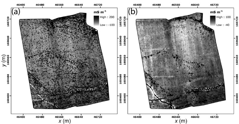
World War I (WWI) battlefields contain a large diversity of buried features that are situated just below the plough layer. A noninvasive interdisciplinary approach is preferred to characterize the buried heritage embedded within its soil landscape. In this study, the potential of integrating both electrical conductivity and magnetic susceptibility measurements from a multireceiver electromagnetic induction (EMI) instrument at a heavily shelled WWI battlefield was evaluated. Primarily, both measurements allowed the attribution of approximate depth interval to the buried trench remains. These remains proved dominantly present within the 0.4–0.8 m depth interval. Subsequently, both apparent electrical conductivity and magnetic susceptibility measurements were separately integrated to improve the contrast between buried features and their surrounding background. Trenches that were ditches filled with topsoil material could be distinguished from trenches that were continuously or partially filled with metal reinforcements or debris. To conclude, integrating multiple signals from a multireceiver EMI system allowed for a more straightforward
discrimination of the buried WWI relicts.
Reference:
Saey, T., Gheyle, W., Stichelbaut, B., Bourgeois, J., Verplaetse, S., Van Eetvelde, V., Note, N. & Van Meirvenne, M. (2016). The Characterization of a Former World War I Battlefield by Integrating Multiple Signals from a Multireceiver EMI Soil Sensor. Geoarchaeology, 31 (4), 267-281. doi: 10.1002/gea.21562