Study of the Rural Landscape – Innsbruck & Seefeld (AU)

(September 2016)

Identifying relations between the dynamic military landscape and network of linear features throughout the Great War

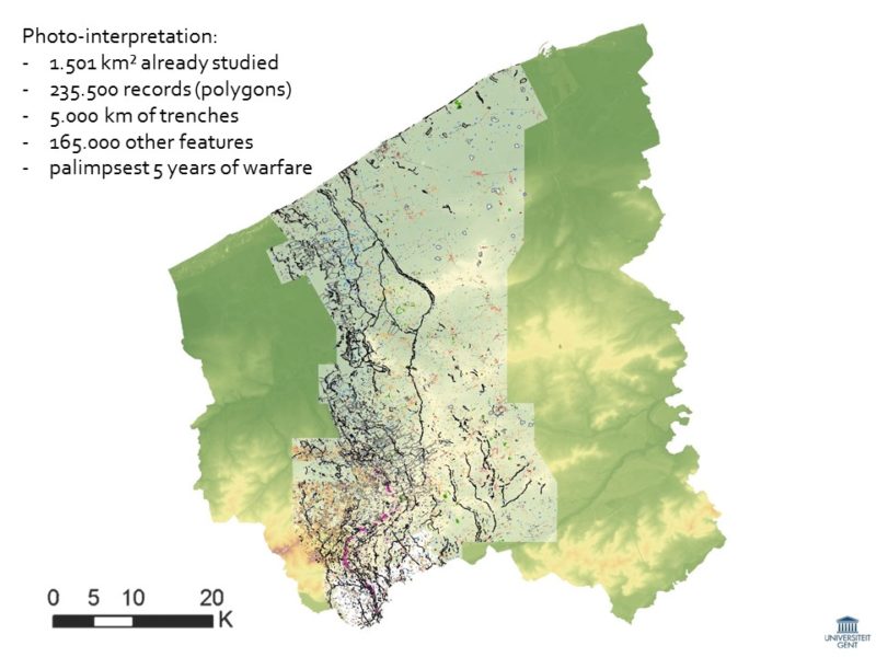
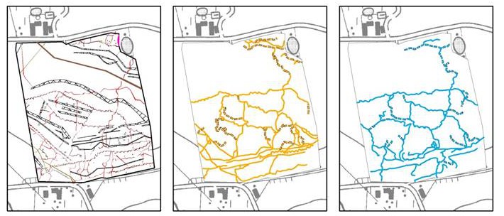
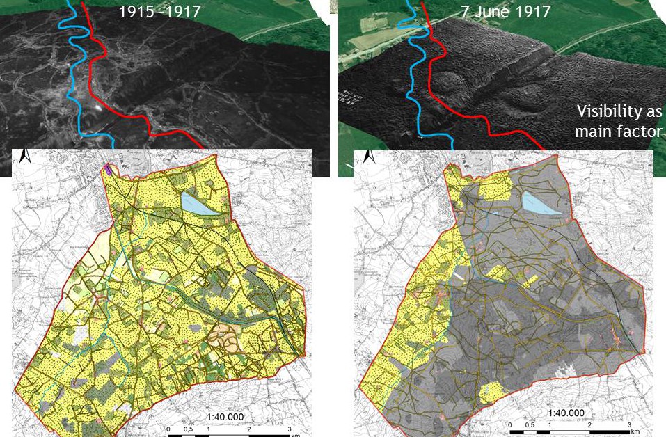
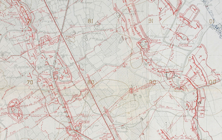
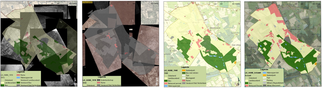
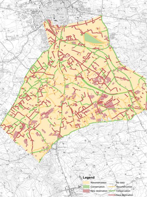
During the Great War the impact of the conflict on the landscape in the western part of Belgium along the front line was enormous. Throughout this war, aerial photographs were taken for military purposes to provide insights into the strategy of the enemy. Today these valuable historic photographs can be used to analyse how the landscape changed during the war and to make inventories of military features. In this paper we want to present an interdisciplinary method to analyse historic aerial photographs. The research area is located in the western part of Belgium, more specifically the area south of the city Ypres (Heuvelland). This area was completely transformed during the war into a military landscape. The first aim of this paper is to understand how land use and linear structures (road network, military features like communication lines and railways) changed during the war. Secondly, the changes of the military linear network which was being developed alongside the trench war are analysed. Landscape change trajectories as well as military features were mapped throughout the war period based on the historical aerial photographs. In addition, we also studied the topography of Heuvelland based on a LIDAR elevation model. Based on this landscape analysis and remote sensing archaeology, we were able to study the changes of this historic network and to combine it with the topography and the landscape change trajectories. The analysis shows different dependent relations between the network and the specific topographical and landscape conditions, which differ along the frontline, on the one hand, and the different military tactics of the different parties, on the other. Finally, by way of conclusion, we want to emphasize the usefulness and contribution of the historic aerial photographs in an interdisciplinary non-invasive landscape research method, combining landscape analysis, remote sensing archaeology and geophysical soil sensing data.

Van den Berghe, H., Gheyle, W., Stichelbaut, B., Note, N., Saey, T., Bourgeois, J., Van Meirvenne, M., Van Eetvelde, V.

Permanent European Conference on the Study of the Rural Landscape

Aerial Archaeology Conference 2016 – Rome (IT)

Aerial Archaeology Rome(February 2016)

Traces of War: Combining Airborne Laser Scanning with Great War Aerial Photographs

In spite of an increase in World War I-related excavations in Flanders (Belgium), little is known about the exact nature and extent of the buried heritage of WWI from research on a landscape scale. The research project ‘Non-Invasive Landscape Archaeology of the Great War’ (see poster session) combines archaeological research, analysis of historical WW I aerial photographs, multireceiver EMI soil sensing and landscape analysis to acquire a concrete understanding of the archaeological preservation of WW I heritage along the Western Front in Belgium.

Historical aerial photographs are an excellent source to study the war landscape. All the more if the results are combined with archaeological field surveys or ALS data in search for above ground remains and non-invasive geophysical research that gives an idea of the archaeological preservation under the plough soil.

This contribution examines the possibilities of the newly available Airborne Laser Scanning (ALS) dataset for Flanders, with an average point density of 16 points per m² (DTM-Flanders II 2013–2015). Different visualization techniques are applied to enhance the visibility of micro-topographical features, in that way identifying fighting trenches, shell holes, railways, tracks etc. as archaeo-geomorphological features in the present-day topography. The ALS-visualizations of the study area were confronted with the GIS mapping of WW I features on 24,000 georectified historical aerial photographs, to examine the present-day degree of above ground preservation of the different war relics in the landscape.

This preservation is directly linked to the landscape changes during and after the war, from destruction over reconstruction to a century of land use and development. It is no surprise that the scarce wooded areas contain a large percentage of preserved WW I structures, but a surprisingly high amount of grasslands also proof to reveal above ground traces of the war. The landscape analysis can definitely be used to point out possible terrains that are certain to hold archaeo-geomorphological traces of the former conflict. Selecting only areas with a landscape trajectory that enables relief preservation (e.g. parcels that were never ploughed) considerably narrows down the intensive analysis of the ALS dataset (with a total research area of about 1.500 km²). This way, a previously unknown and substantial part of our WW I heritage has been identified; hundreds of grasslands and wooded parcels in Flanders show preserved surface traces of WW I. That is unexpected, and highly important for the archaeological preservation of the war features below ground – those lands haven never been worked, ploughed, levelled or altered in any other way.

Rediscovering the Great War – Ljubljana (SL)

Inventory of WWI traces(May 21, 2015)

The World War I conflict landscape in Belgium. A confrontation between past and present through non-invasive survey techniques

The World War I Western Front is one of the largest continuous archaeological sites in the world. Although fragmented archaeological surveys and inventories of related conflict heritage have been conducted, an overall landscape archaeological investigation of the Belgian front has not yet been achieved. The nature and extent of the buried heritage is thus largely unknown, in spite of an increase of World War I related excavations in Flanders during the last decade. We developed an integrated aerial archaeological and GIS-aided approach to assess this war heritage, combined with landscape research and geophysical prospection. Preliminary results suggest an excellent subsurface preservation of the conflict landscape, even after the devastating effect of war itself and a century of reconstruction and land use. Inevitably, questions about the presence, nature, diversity and value of this heritage will be raised, together with considerations of the need for preservation of remains and their treatment in infrastructure developments (agriculture, industry, urban). Such complex questions cannot be answered only by traditional archaeological field investigations but require an interdisciplinary non-invasive approach conducted on a landscape scale.

Historical aerial photographs are an excellent source to study the war landscape. All the more if the results are combined with archaeological field surveys or Lidar data in search for above ground remains and non-invasive geophysical research that gives an idea of the archaeological preservation under the plough soil. This approach combines three dimensions into one dataset: firstly a birds-eye view of the situation in 1914-1918; secondly the present-day landscape scattered with remains, from military cemeteries and pillboxes to subtle micro topographic traces of trenches and bomb craters; and finally a detailed view of preserved subsurface features such as trenches and dugouts.

This methodology is the foundation for a study of the entire Belgian front zone in the interdisciplinary research project ‘Non-Invasive Landscape Archaeology of the Great War in Belgium’. Although the inventory of war features on our dataset of some 24,000 georectified aerial images coming from war archives worldwide is still ongoing, already 4875 km of trenches and over 165,000 of other military structures have been identified in the surveyed area of 1457 km², along a front line of only 67 km. In this paper, we will present a detailed study of the part of this conflict landscape using a transect through the shifting frontlines and both hinterland zones, showing the vast war infrastructure and consequent war destruction, and giving insights into their possible archaeological preservation.

Conflict in Contact – Vroenhoven (BE)

Aerial photo-interpretation vs. geophyisal research(November 14, 2014)

Electromagnetic induction (EMI) on a conflict landscape of the Great War: Chemin du Mont de la Hutte, Ploegsteert

In spite of an increase in World War I-related excavations in Flanders (Belgium), little is known about the nature and extent of the buried heritage of WWI from research on a landscape scale. This paper examines the combination of historical aerial photographic evidence and geophysical soil sensing. A case study in Comines-Warneton compares data derived from contemporary WWI aerial photographs with multi-receiver electromagnetic induction surveys. This comparison provides an understanding of the degree of preservation of trenches, dugouts and other military structures, and illustrates the added value of integrating both techniques in an in-depth, non-invasive study of conflict landscapes.


CHeriScape II: Landscape and Heritage in Science and Research – Amersfoort (NL)

CHeriScape Amersfoort_1

(November 5-7th 2014)

Non-invasive landscape archaeology of the Great War as baseline for an integrated heritage management

The commemoration of the World War I increased the attention to the Great War in research, policy, application and public awareness. Several research initiatives and inventories of the military heritage are set up, cultural and tourist visits are a booming business, and regional authorities are initiating sustainable heritage management and activities paying attention to the distinctive military features and landscapes. However, to unravel the complex reciprocal interaction between landscape as the last witness and the ware activities in time and space, an interdisciplinary approach is appropriate.

The paper will present two cases of inter- and transdisciplinary research related with landscape and World War I heritage. The first case is situated in the former battlefields and hinterland of the Great War in Belgium, where a interdisciplinary research project is set up with the overall question how the buried heritage of a former war zone within the present landscape can be characterised using a non-invasive methodology. The landscape archaeological project combines three different disciplines: remote sensing archaeology, geophysical soil sensing, and historic and visual landscape analysis, which are all go beyond the current state-of-the-art within the disciplines as well as enriching each other to come to an integration of knowledge acquired within these disciplines toward an interactive cartographic assessment model.

The second case is a World War I defensive trench line in the north part of Flanders, where a detailed inventory of the military relics and landscape formed the baseline to formulate an over-all vision for sustainable future cultural management of the militarized landscape. This research developed into the implementation of the conservation of these areas and razing awareness in a transdisciplinary way.

Veerle Van Eetvelde, Stephanie Verplaetse, Wouter Gheyle, Birger Stichelbaut, Jean Bourgeois, Timothy Saey, Marc Van Meirvenne

Cartography in Times of War and Peace – Ghent & Brussels (BE)

Systematic analysis of trench maps to understand the Belgian World War One front zone landscape

(December 2-6 2014)

Systematic analysis of trench maps to understand the Belgian World War One front zone landscape

5h International Symposium of Cartography in Times of War and Peace, Ghent and Brussels, Belgium,  – more information

Verplaetse, S., Stichelbaut, B., Gheyle, W., Saey, T., Bourgeois, J. Van Meirvenne, M. Van Eetvelde, V. (2014) Systematic analysis of trench maps to understand the Belgian World War One front zone landscape – abstract

Study of the Rural Landscape – Gothenburg & Mariestad (Sweden)

Using military cartographic sources to reconstruct the Belgian World War One front zone

(September 8-12 2014)


Using military cartographic sources to reconstruct the Belgian World War One front zone

PECSRL2014 – 26th session of the Permanent European Conference on the Study of the Rural Landscape. Unraveling the logics of landscapes, Gothenburg and Mariestad, Sweden – more information

Verplaetse, S., Gheyle, W., Stichelbaut, B., Saey, T., Bourgeois, J. Van Meirvenne, M. Van Eetvelde, V. (2014) Using military cartographic sources to reconstruct the Belgian World War One front zone – abstract

ArcLand Conference – Poznan (Poland)

Landscape characterisation of Belgium’s war zone

(April 24-26th 2014)

World war one from a bird’s-eye view. A Landscape characterisation of Belgium’s war zone

ArcLand Conference. Patterns, Processes & Understanding: historic aerial photographs for landscape studies, Poznan, Poland,  – more information

Verplaetse, S., Dossche, R., Gheyle, W., Stichelbaut, B., Saey, T., Bourgeois, J. Van Meirvenne, M. Van Eetvelde, V. (2014) World war one from a bird’s-eye view. A Landscape characterisation of Belgium’s war zone – abstract